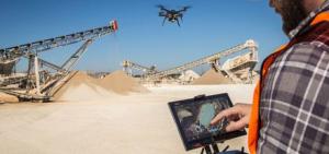
Site Scan drone and software package makes it easier for firms to capture images, data
A new application from 3DR paired with its Solo smart drone will make it easier for oil and gas companies to keep an eye on their operations.
Site Scan is an aerial analytics platform that uses the latest innovations in capturing images from Sony and Aerodesk cloud processing capabilities to provide an end-to-end solution for companies to gather data and images, says Jeremiah Johnson, a vice president at 3DR.
“When Site Scan is paired with our Solo drone, anyone can fly it,” he says. “You don’t need to hire a separate operator – your current crew can do it. Using the app, you can circle the area you want to photograph by drawing on the tablet with your finger and it goes up, flies to the area and photographs what you need done.”
Site Scan’s versatility allows it to do everything from photographing an area and immediately transmitting the images back to crew members, to capturing data that can be used to create high-resolution georeferenced maps and digital elevation models while Scan photographs the area to create a 3-D model. When the drone returns to base, the information can be uploaded to the Aerodesk cloud where it can interface with engineering programs.
“You can send the drone out to inspect a pipeline or rig and see immediately if there’s something that needs to be addressed,” Johnson says. “Companies can then send out their crews if repairs are necessary.”
The Site Scan package includes the Solo drone, a Sony Xperia tablet with the Site Scan app, a Sony UMCR10C or GoPro Hero Black camera, unlimited storage in the 3DR cloud and unlimited processing and publishing credits with the Autodesk Cloud.
“Site Scan saves companies money by saving them time. It cuts down the need for a drone pilot and travel costs,” Johnson says.
“The app can be used at all different parts of the gas and oil cycle – upstream, midstream and downstream,” he continues. “Upstream, you can photograph the rigs or survey an area; midstream you can photograph pipelines; and downstream it can be used at a refinery to make maps to track your assets. The possibilities are endless.”
The product’s versatility combined with its ease of operation attracted the McKim & Creed engineering firm to invest in the technology, says R&D manager Christian Stallings.
Site Scan combined with the Solo drone “is a solution that combines intelligent hardware, intuitive software and camera systems built for mapping, not movie making,” he says. “3DR is truly changing the way that people will think about professional mapping drones."
Johnson says flying the drone is fairly simple. Users can draw on the tablet’s screen with their fingertip to define geofences – including areas where drones are not permitted – and the drone will not cross into those areas.
“Every flight is safe,” he says. “The Site Scan app includes 3DR’s airspace safety information software, which alerts users if they’re about to fly in restricted airspace. They can then pull up a map of the area with all restrictions around them clearly marked.
The technology works well in a variety of temperatures, Johnson says.
“We used it in Dubai when it was 38 degrees Celsius and in Norway when it was -15 Celsius. I tell people it works in weather that you would be comfortable working in outside. You can use it when it’s drizzling, but probably not when it’s pouring.”
When designing Site Scan, 3DR made it an open, extensible platform, Johnson says. The Solo smart drone has open gimbal and accessory bays, which gives both 3DR and its technology partners the ability to add more cameras and sensors. The Solo firmware updates also optimizes the drone’s flight profile and performance. 3DR also plans to continually update the Site Scan app so customers have the most recent and advanced analytics technologies, he said.
“Technology keeps evolving and we’ve designed Site Scan to evolve with it,” Johnson says.


Comments